

The morning brought cold light and fresh snow on the cars.
My father had already been out. He came back in stamping his feet, dropped a newspaper on the table, and opened a bag from the grocery a block away: bananas, apples, a package of sweet rolls, a pint of milk. He’d had his thermos refilled at the counter. While we ate, he spread the December 16 Chicago Tribune on the table and showed us the front page.
Two inches of snow on the ground. Another inch overnight. Sub-freezing temperatures were glazing the roads. The Chicago Motor Club was urging extreme caution. The article mentioned twenty-six sand-and-salt trucks working through the night to clear the city streets. My father had already talked with the store owner, who told him schools were closed and the roads into the city were quiet — not much traffic going in.
That was enough for him.
He’d been driving in snow since he was sixteen. For a couple of years he’d run a milk route, finishing his deliveries about the time most people’s alarm clocks went off — in winter, on whatever roads the night had left behind, a truck loaded with cases of milk. My mother didn’t try to talk him out of it.
We bundled into the DeSoto and crept out of the gravel lot, tires crunching through the white. The landscapes on either side of the road were bare and bleak — stripped fields, leafless trees, the occasional barn — everything pulled flat and gray by the cold. I watched it through the window as we crossed into Illinois.
Then Chicago. The city rose out of the flat land, steel and stone and smoke, and for a few minutes we caught glimpses of Lake Michigan to our east before we were in among the tall buildings, the car slowing, the streets still lightly traveled out of respect for the frozen roads.
My mother pointed. “That’s the Art Institute of Chicago.”
It filled the block, stone lions flanking the wide front stairs. My father found a place to pull over and pointed across Michigan Avenue to a highway shield on a signpost — a white shield with a black border and the number 66.
“That’s it,” he said. “That’s where Route 66 begins. And it’s going to take us all the way to California.”
He had told us about it the night before, drawn it on a napkin at the diner. Now it was real. The starting line.

Route 66 had been real for a long time before we found it that December morning.
The road was designated on November 11, 1926, assembled from a patchwork of existing local and state highways rather than built from scratch — which is why it threaded through the centers of towns and cities rather than bypassing them. From Chicago it ran southwest through Illinois and Missouri, dipped into the southeast corner of Kansas, crossed Oklahoma diagonally, cut across the Texas panhandle, and then turned west through New Mexico and Arizona to Los Angeles. By 1938 it was the first highway in the country to be completely paved, 2,448 miles of it, end to end.
But the road’s story — what made it mean something — was told by the people who had traveled it before us.
In the 1930s it was the Dust Bowl road. Drought and economic collapse sent thousands of families from Oklahoma, Arkansas, and Texas west along Route 66 toward California, looking for anything better. John Steinbeck watched them go and wrote The Grapes of Wrath, giving the road its most lasting name: the Mother Road. The Joads traveled it in desperation, with everything they owned lashed to a truck, heading toward a California that turned out to be something other than what they’d been promised.
We were traveling it in optimism. We weren’t escaping anything. We were seeking something — a vibrant economy, a climate that would suit us better, family already waiting on the other end. The country was in the beginning of a massive 1950–70 migration that largely accounted for California nearly doubling in population, from 10.6 million to 19.9 million.
As Dad eased the car into traffic and we began our first mile on US 66, I assumed my favorite viewing spot. When I was little, I would stand on the front edge of the back seat and lean forward against the front seat. Now I could stand on the hump in the floor and watch the road ahead. Patty was still settled in Mom’s lap. Next to them on the seat were a few road maps, ready when needed. We were — and would always be — Triple-A members. But good road maps were always available at bigger service stations, too. My mother was an experienced navigator and always gave my father plenty of notice when the next turn was coming. Since we were going to be staying on this road like, forever, I hoped I would have lots of time to use the maps myself to follow our route. I loved driving through towns and cities that had been just dots on paper. What I didn’t love was trying to get the maps folded again.

My father had been thinking about the Mother Road — also known as the Will Rogers Highway and the Main Street of America. Once we were out of the city, heading southwest through the flat Illinois winter, he talked about it — the way he always talked, less like conversation and more like teaching. In a good way. He told us how the Road had started as Indian trails, then wagon roads, then a series of local highways that got stitched together and numbered 66. How it had been the military supply line during the war. How after the war, everybody who had a car and somewhere to go seemed to end up on it.
Now, we were part of that.
From Chicago, Route 66 ran southwest through Joliet, then on through Pontiac, Bloomington, Atlanta, Lincoln, and Springfield — small Illinois cities strung along the road like beads, each with its filling stations and diners and motor courts arranged for the convenience of people passing through.
South of Joliet, somewhere along the flat middle of Illinois, I opened my piggy bank.

I’d been saving it for months. The piggy bank was the kind with a cork in the bottom, and I’d been promised that if I filled it without opening it, the money would be mine to spend on souvenirs along the way. Now I pried out the cork and poured the coins onto the sleeping bag nest I’d made on the floor of the back seat — pennies, nickels, dimes, quarters, even a couple of half-dollars, the full weight of months of accumulation.
I sorted them into piles. Found the oldest ones: buffalo nickels among the Jeffersons, Mercury dimes among the Roosevelts. My dad gave me problems to solve from the front seat. If something costs thirty-seven cents, how many ways can you make change? If you have a quarter and two dimes, what can you buy at a diner? I worked through them slowly, the arithmetic mixing with the rhythm of the road, deciding how to budget so I’d have something left for Palm Springs.
Time passed that way, which was the whole point.
Springfield was Lincoln country. The road ran past the state capitol, past the neighborhood where Lincoln had lived, past the sites that drew tourists even in December. My father did stop here — he wouldn’t have driven past Lincoln’s house without marking it — though my clearest memory of Springfield is the motor court that night: the smell of the room, chenille spreads on the two beds, the radiator clicking against the cold outside. We’d covered nearly 300 miles since Gary. Day one on Route 66, done.

Next morning, the Mississippi came up on us without warning — or it felt that way to a five-year-old who had never seen a river more than a hundred feet wide.
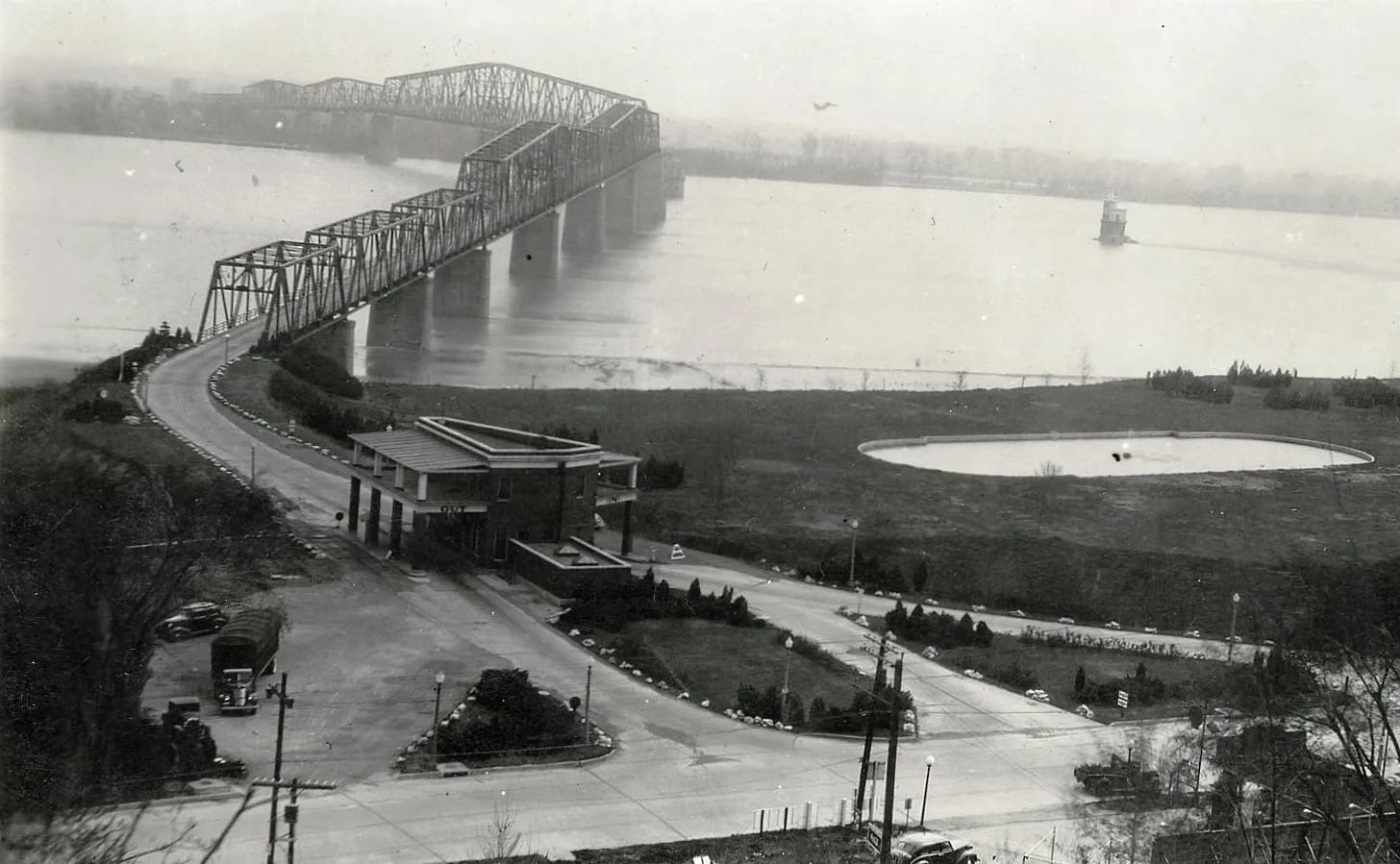
The old Chain of Rocks Bridge was the Route 66 crossing into Missouri, a steel-truss span built in 1929 with a peculiar 22-degree bend at its middle, so the road jogged sideways over the water before straightening again on the other side. I don’t remember the jog. I just remember — because it was Mom who said it — that the mile-long bridge was green because it was painted that color to be less visible from the air during WWII. As I stared out the window at the Mississippi River I may have been thinking it seemed too vast to be a mere river. And my mother may have been reading my mind when she said it was also known as the Father of Waters.
Then my father — true to form — couldn’t help asking if I knew how to spell Mississippi. Mom gave him a look as he crowed, “M-I-crooked letter-crooked letter-I- crooked letter-crooked letter-I-humpback-humpback-I.” She just shook her head. But, after a few reminders I’m sure, I remembered it the rest of my life.
Then we were in Missouri, with St. Louis ahead of us.
The city sat at the confluence of the Missouri and Mississippi rivers, the gateway from east to west for a century and a half, with the famous Arch still a decade away. Lewis and Clark had set off from here, the Oregon Trail had started here, and half the westward migrations in American history had crossed the Mississippi at this bend. We were just the latest. We spent night two somewhere in the city, in a motor court on the western edge. Before I fell asleep, I thought about what my mother had called the river and that we had crossed the Father of Waters on the Mother Road.
In the morning the road climbed into the Ozarks.
Missouri changed the feel of the trip. Illinois had been flat and familiar — not so different from Michigan or Indiana. Missouri was something else. The road wound up into forested hills, limestone bluffs rising on either side, the skeleton trees of winter silhouetted against the steely blue sky. That sky seemed bigger. The road seemed older.
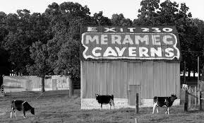
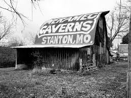
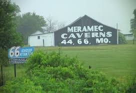
My father spotted the barn signs west of St. Louis.
They’d been appearing for miles: painted on the roofs and sides of barns and outbuildings in white letters, the same two words over and over — MERAMEC CAVERNS. The caves had been open as a tourist attraction since 1935, opened by a man named Lester Dill who understood that Route 66 travelers would stop for almost anything if it was promoted aggressively enough. The barn-roof advertisements ran for hundreds of miles in both directions. I had been reading them aloud since Illinois.
We stopped.
The caverns were cool and enormous — a constant 60 degrees year-round, which felt warm after the December air outside. The tour guide told us the caves had been a hideout for Jesse James, though he hedged on the details. Stalactites and stalagmites rose and hung in formations that had been growing for four hundred million years. The World Book Cvolume had caves in it; I had studied the pictures. The real thing was better.
My mother bought a postcard at the gift shop. She had us write our names on it that night at the motel, then took it to the office front desk to be mailed to my grandparents in Palm Springs.
We are on our way. We signed it Pat and Mike, the way our grandfather liked to refer to us. Like the Hepburn-Tracy movie.
That was night three — the Ozarks somewhere west of Meramec, Springfield Missouri still a short drive ahead in the morning.
The fourth day brought us down off the Ozark plateau and through Springfield, Missouri. This is the Mother Road’s self-proclaimed birthplace, though the good people of Tulsa do the same self-proclaiming. Then the land began to unwind. Kansas came and went in thirteen miles, just enough of a corner to say we’d been there, and then the long diagonal drop into Oklahoma.
We crossed into Oklahoma on a frigid morning, the sky white and the land opening up around us.
Missouri had been hilly and wooded, folded in on itself. Oklahoma was the opposite — flat, wide, the horizon pushed back to where it seemed to blur into sky. The fields went on until they stopped making sense as fields and became something more abstract, something about distance itself.
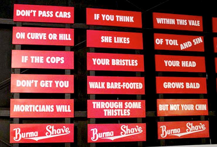
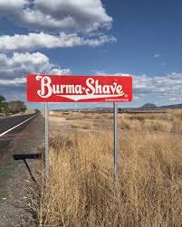
With less to see out the windows, it was the perfect place to try to read as many Burma Shave signs as we could. Sets of six signs, spaced 100 feet apart on straight stretches of highway, proliferated across 45 states. By December, 1953, there were nearly 7,000 sets. Oklahoma and Texas had a disproportionately large share of them and lots of straightaways on Route 66. I doubt we were aware of it, but we wouldn’t be seeing these signs once we crossed the Texas-New Mexico border. New Mexico and Arizona prohibited them along their roads. But they were otherwise a fixture since 1926. Farmers voluntarily repaired them, radio comedians satirized them, and college students decorated dorm rooms with them.
Unlike today’s freeways, people didn’t speed along The Mother Road. We probably averaged 40 mph on our trip. That, combined with long sightlines in flat, open, rural Oklahoma and Texas, made the signs easy to spot and read. And they were a great antidote to a 5-year old’s boredom. Even Patty delighted at the sing-song rhymes as my parents and I read them together. She would join in when we all shouted the final sign’s “Burma Shave!”

After one “Burma Shave!” when the giggling had died down, my father got quiet for a while, which was unusual. Then he told us about the Dust Bowl.
In the 1930s, he explained, the rains had stopped across this whole region — Oklahoma, Texas, Kansas, the panhandle. The topsoil had dried up and blown away in storms that turned the sky black at noon. Families had lost everything — farms, savings, any reason to stay — and loaded what was left onto trucks and cars and driven west. Route 66, through these same fields we were looking at, had been jammed with them. Some of those families were heading to the same part of California we were heading to now.
I looked out the window at the flat brown land and tried to picture it.
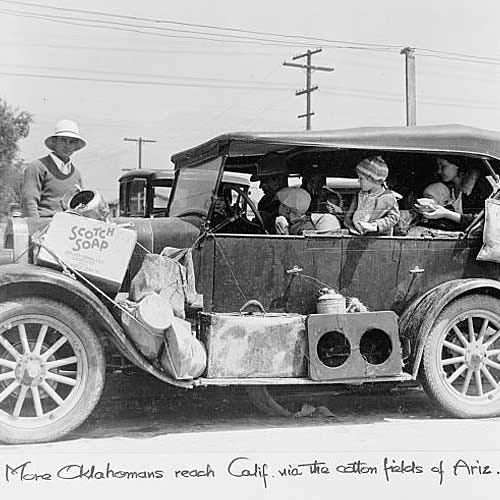
By the time we were driving through, Oklahoma had recovered — the fields were planted again, the towns were functioning, the cafés along Route 66 were full of truckers and travelers. But the memory of those years was fresh in the people who had lived through them, and the landscape still held the hard look of a place that had seen hard times.
That same year, 1953, Oklahoma had opened the Turner Turnpike between Tulsa and Oklahoma City — 88 miles of divided, high-speed highway that bypassed every town Route 66 ran through. It was called progress. It was also the first sign of what was coming for the old road, though nobody was ready to read it that way yet.
We came into Oklahoma City in the late afternoon, the road wide and busy through the city center. We spent night four there — a motor court on the western edge of town, the kind of place where you pulled up directly in front of your door and the office had a rack of postcards and a Coke machine in the lobby. The rooms smelled of cigarette smoke and cleaning fluid and the accumulated passage of everyone who had come through before.
In the morning we turned west. The land flattened further and the sky took over. The Texas panhandle announced itself before we crossed the state line.
The land had been wide in Oklahoma. In Texas it became something else — immense, indifferent, a landscape that made the car feel very small. The road ran straight west toward a horizon that never got any closer, the December sky pale above the brown and yellow grass, nothing taller than a fence post for miles in any direction.
There wasn’t much to interest us outside and Patty and I began to spend more time entertaining each other. Down on our padded floor, I let her pour the coins out of the piggy bank. Most were still unspent. She sorted the coins into piles. I taught her their names and she called out, “Penny, penny, dime, quart, nickel,” as she dropped each one back in the pig through the slot. After another dump of coins and a reminder that the big ones were called quarters, not quarts — I had pocketed the half-dollars early on for safe keeping — Patty got about halfway through the pile, gave a few big yawns, curled up on her side and slept.
The Texas panhandle along Route 66 had been Dust Bowl country, too — some of the most devastated land in the region during the 1930s, the topsoil stripped by drought and wind and carried away in the black blizzards that gave the era its name. By 1953 it was cattle and oil country, trying to be prosperous again, with Amarillo as its capital.
Amarillo was the only major city on the Texas stretch of Route 66, and by 1953 there were sixty-eight Route 66 lodgings operating in the city — motor courts, tourist cabins, roadside hotels — a full ecosystem built to receive travelers and send them on their way. We stopped for the night somewhere in or near Amarillo in one of those sixty-eight lodgings. It would most likely have been windy ever since we crossed into Texas, a flat relentless push from the northwest that could rock the car and make the motel sign creak all night.
School teachers — and research — will tell you wind is associated with restlessness, irritability, inattention, and increased anxiety. Or perhaps we were just experiencing a cumulative weariness after several days on the road. Either way, we were more tired than hungry. Plus, Patty was coming down with a cold. So, rather than going to the diner up the road, we made our dinner with what leftover lunches and snacks were in the car. Mom was reading us a bedtime story, but Patty was asleep after just a few pages. We all soon followed her example.
Nice story between you and AI. Claude may have inserted a slightly inaccurate statement, though, when Route 66 is described as the longest paved road, "from coast to coast," when it starts far from the East Coast in Chicago.